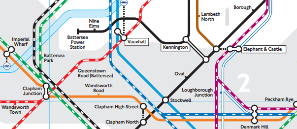
TfL have released the new versions of the tube map, and London’s rail and tube services map, including the soon to be opened extension of the Northern line. First up is a snippet of the tube map:

And next is the same area on the combined rail and tube services map:

Both have coped as well as they could with the constraints of showing the extension in zone 1 while maintaining Vauxhall on the boundary between zones 1 and 2. The dotted interchange between Vauxhall and the river pier is maintained in spite of the need to cross the line of the extension. It’s disappointing that they don’t show the new walking interchanges between Battersea Power Station and Battersea Park or Queenstown Road. The rail and tube map is also quite messy about the zone Kennington is in. The station name is boxed which means it is dual zoned, but the blue shading above the Bank branch blob suggests that it is in zone 2. In contrast, the tube map has it just right.
The most surprising omission for me is the link between the Charing Cross branch of the Northern line and Oval station. There are still a number of peak services which use this link and it is clearly shown on the in-carriage maps:
 And the posters on display at Northern line stations still show it as a full service option:

In geography errors I didn’t foresee, Kennington now being depicted north of Elephant and Castle is very hard to get used to!
Ha! I see what you mean. Sadly it was inevitable with the need to run the line above Vauxhall without making it a confusing zig-zag.