Over the years since Oyster was rolled out there have been a number of new interchanges added to the system. Notable among those have been Warren Street to Euston Square, Bayswater to Queensway, Aldgate to Aldgate East and Cannon Street NR to Bank. More recently a tranche of new interchanges appeared to service the Elizabeth line, including at Custom House, Canary Wharf and between Bond Street and Oxford Circus.
The current tube map includes dotted lines between nearby stations which many people think ought to all be interchanges. Sadly some are not, including the potentially useful Harringay Green Lanes to Manor House and the less useful Swiss Cottage to South Hampstead. There are also some pairs of stations which people seem to use as interchanges even though they are not. South Acton to Acton Town is one such example because the alternative is to change at Gunnersbury, Turnham Green and Acton Town. Sadly the street distance is more than the usual limit of 10 minutes walk so I don’t think we’ll see that one anytime soon.
So, where does Whitechapel fit into this and why is it a particular problem, I hear you say. Well, Whitechapel and Bethnal Green (Overground) stations are actually pretty close. Google thinks you can walk between the two in 8 minutes which is well within the distance usually associated with interchanges. It’s an interchange which has been asked about many times, since Bethnal Green was served by Greater Anglia trains and the Elizabeth line was years away from completion. Now it’s completely served by TfL run services and the aforementioned Elizabeth line provides a number of new opportunites from the West Anglia lines.


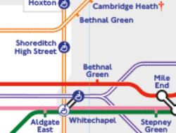
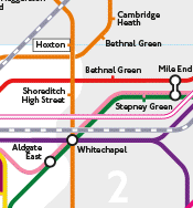
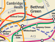
But historically the positioning of lines and stations on maps in the Bethnal Green area has been distorted by the desire to simplify the looping of the Central line. The left hand image is taken from the “London’s Rail and Tube Services” map while the right hand image is from the Tube map. In both cases Whitechapel and Bethnal Green (Overground) are depicted a long way apart, compared to Bethnal Green (Central) or even Shoreditch High Street. The image below is taken from a geographical map published a few years ago in an FOI request. You can clearly see there that the two stations are in fact close together.

Now, to add to all the geographical evidence I asked TfL for daily figures over a four week period where people touch out from Whitechapel and touch in at Bethnal Green (Overgroud) within 20 minutes, and the same in reverse. The result shows that around 100 people are making the interchange in each direction each weekday. This means it’s more popular than Aldgate to Aldgate East and all without any advertising at all.
Some of the people may be using travelcards, but a fair number will be PAYG where they are being charged for two journeys rather than one. My belief is that if they redraw the map with interchange dots and symbols, and add an OSI, then a lot more people will make use of the proximity of the stations and avoid a trip into zone 1. I will be following up this matter with TfL.
I wonder if one of the reasons is to stop passengers from South London using it as another way to avoid the Zone 1 surcharge at Shoreditch High Street on the ELL which was introduced to protect revenue for Southern (now GTR).
At the moment, if I want to change for the West Anglia lines from the ELL and avoid the Zone 1 fare is to travel via Canada Water and Stratford using the Jubilee and NLL and change at Hackney Central for Hackney Downs and touch the pink reader, otherwise the default fare is via Zone 1 and you can change at Canonbury and Hackney Central.
It’s possible, but as this requires a walk between stations I think that’s a red herring. The main reason for Shoreditch High Street being in zone 1 is that it is closer to Liverpool Street than the old station. This increases the number of people who would use it as their destination.
Is there any follow up on this interchange? It is the fastest route to travel from SE London to most places on the Weaver line, such as London Fields, since the Elizabeth line opened.
I’ve had a lot of issues with regular FOI requests in the last couple of years, so no, there isn’t any progress as yet. However, as it’s a new year I am tempted to put a new request in. Whether they are inclined to make any changes is another matter, but we’ll see.