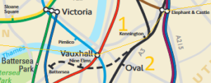
Today the zone 1 boundary moved south to Kennington station and then along the Northern line to Elephant & Castle. This means that Kennington is now on the boundary between zones 1 and 2 rather than in zone 2 alone. The reason for this is because the new Northern line extension to Nine Elms and Battersea Power Station will be in zone 1 as part of the agreement with the owners of the new development. They have been promised zone 1 status so that fares to the rest of Central London are not inflated by an extra zone.
 This is all very well, but what about Vauxhall? As you can see on the map, Vauxhall is very definitely north of the new extension. Like Kennington and Elephant & Castle it is currently in zones 1/2, meaning that passengers travelling from the south do not incur a zone 1 fare. Now I readily admit that you can’t get from Vauxhall to either of the new stations directly, so there isn’t a technical problem in the same way that there was at Kennington. But just how are they going to show the zones on the map?
The diagramatic tube and rail maps could push the extension above Vauxhall. It wouldn’t be the first time something like this had happened (just look at Bethnal Green), but I can’t help thinking it would be confusing if they do. A more radical approach would be to put both new stations in a zone 1/2 sausage (like Stratford to Canning Town) but they’d then have to charge zone 2 fares between Battersea and Elephant & Castle.
“But just how are they going to show the zones on the map?”
AFAICS, no one is confused by the London Trams Fare Zone’s awkward mapping. No one thinks you’d be charged a tram fare between Waddon and West Croydon, Morden to South Wimbledon, etc despite crossing the zone without stopping in it.
Therefore having a weird shaped Z1-2 boundary would work, even though either the Victoria line between Stockwell and Vauxhall enters Z1, or the Northern line between Kennington and Nine Elms enters Z2. Though given your, and Geoff Marshall’s, remarks on this issue, perhaps I’ve dramatically underestimated the problem.
So let’s assume confusion and go with the slightly uglier solution of putting Elephant, Vauxhall and Kennington in a Z1/2 specially-marked zone (like the 2/3 one in East London) and keeping Nine Elms & Battersea PS in Z1, with an odd-shaped boundary (so Nine Elms – Elephant would still be a Z1 fare, not a Z2 one), which would allow both lines to be in the right psuedo-geographic location while not entering the wrong zone on the map.
Well, I’m no fan of including the trams on the tube or rail/tube maps, but given that they are a completely separate mode of transport I don’t think it’s that confusing. It’s also not a zone number.
The more I think about it, the only sensible solution is to pretend the NLE crosses above Vauxhall with just the dotted line to the pier looking odd.